Case studies
Harnessing Deep Learning for Precise Storm Forecasting
Unlocking Nature's Secrets: Deep Learning Techniques Revolutionize Storm Prediction, Ensuring Accurate Weather Forecasts for Safer Communities
Get a quote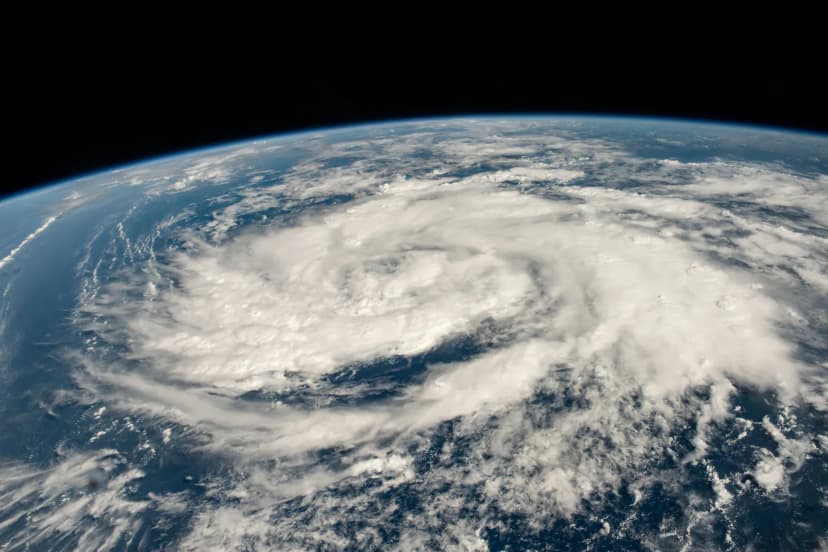
Summary
Anthropogenic activities' contribution to deteriorating climatic conditions has shown a multifaceted global impact. Between 2010 and 2017, 33 European Environment Agency (EEA) member countries suffered an annual average economic loss of approximately 13 billion Euros (based on 2017 Euro values) due to weather and climate-related extremes. Effective extreme climatic event monitoring and forecasting need a framework that enables the regulatory body to take effective action toward human welfare and at the same time improve awareness. Artificial Intelligence (AI) and Machine learning (ML) have become integral to the weather and climate-based decision-making process. ML models can perform post-model bias correction, efficient workflow, and nonlinear relationship mapping within extensive data. Application of a data-driven approach has made significant contributions towards (1) Intermittent but valuable extreme weather event prediction like floods and cyclones and (2) Forecast of continuously acting air quality issues. These models can provide standardized key performance indicators (KPIs) to make business decisions. The primary capability of this framework should be an early and accurate prediction of extreme events with proper uncertainty estimation using state-of-the-art deep learning technology.
Duration
3 months
Team Size
4
01
Challenges
Using AI-powered solutions or tools in extreme climatic event prediction helps scale and enhance human expertise. The consequences of climate change and extreme weather events like storms and their adverse impact on the economy and human life are important research areas.
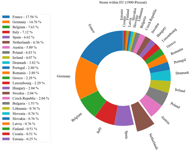 Within EU countries storm events corresponding to the Netherlands are quite significant (6.36%) if compared with frequency of flooding events, hence storm has lower historical occurrence for the EU as compared with Flood but specifically for Netherlands, storm holds the major share.
With the advancement of AI, the interests of academia and the executive branch are shifting towards the application of AI in battling these natural disasters. In case of a flood, there can be two major applications of AI: (1) Application of AI before the storm so that there can be proper storm warnings (forecasting) and (2) Application of AI after the storm event to find out the areal extent of a flood (flood mapping) so that enough and accurate information can be sent away as soon as possible to first responders to reach the target area and risk assessment. With the help of ML/DL, it is now feasible to forecast floods as late as 6 hours before and as early as 1 to 3 days before the event. Flood mapping can also be accurately done so that immediate relief can reach needy ones.
02
Innovation
Numerical Weather Prediction (NWP) data are the most familiar form of weather model data. NWP computer models process current weather observations to forecast future weather. Output is based on current weather observations, which are assimilated into the model’s framework and used to produce predictions for temperature, precipitation, and hundreds of other meteorological elements from the oceans to the top of the atmosphere. These data sources can be a starting point for AI-driven weather forecasting.
Observational satellite images have seen significant acceptance from various domains like transportation, weather, and urban planning due to technological advancements and ease of availability. Satellite imagery helps to continuously monitor the storm's intensity, analyze the storm's direction, and estimate its location.
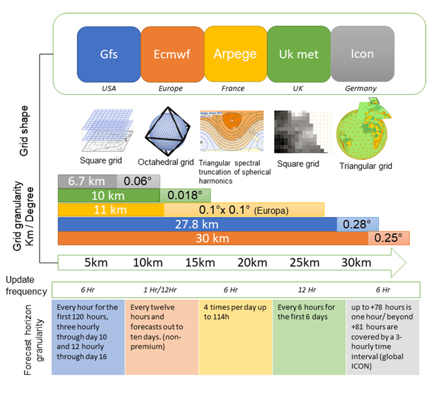 An overview of various NWP sources and their associated parameters. This graph shows the grid shapes and granularities of several forecast models used in the USA, Europe, France, UK, and Germany.
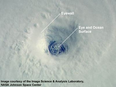
The life of a hurricane begins over warm oceans by taking the energy of warm waters and moist air. As a cyclone takes more energy, it becomes stronger. Without wind shears, the pressure in the hurricane's center drops significantly, and the wind speed will increase. This low-pressure and almost calm center is called the “eye” of the hurricane. An eyewall surrounds the eye area. The eyewall is the most intense and destructive part of a hurricane, made up of thunderstorm clouds and strong winds. The shape of the “eye” from satellite imagery can explain the intensity of a hurricane. A more rounded and symmetrical shape of an eyewall means having stronger hurricanes.
 The hurricane’s eye transitions from uniform to asymmetric shape due to the significant increase in wind shear.
Object detection in satellite images in the context of ramp event prediction could allow us to recognize if there is any visual indicator of extreme events in the satellite images. It also enables us to localize the position of each event using a bounding box. Several methods can be employed to use object detection in satellite imagery, such as the YOLO object detection algorithm, the SSD algorithm, or R-CNN family algorithms.
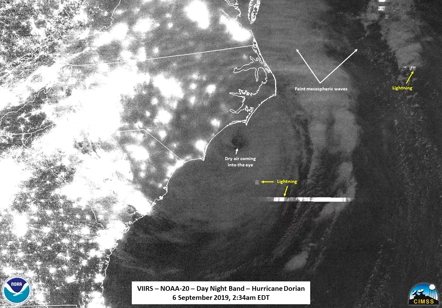 GOES satellites detect lightning activity in hurricanes.
The second type of satellite imagery is microwave imagery data, which is very beneficial for early-stage severe storm detection. When the clouds partially cover the eye, microwave imagery data tracks the storm’s eye.
The Geostationary Operational Environmental Satellites (GOES) satellites can capture lightning activity in hurricanes to predict a one-day earlier hurricane Intensity. The Visible Infrared Imaging Radiometer Suite (VIIRS) can capture visible and infrared images. The day-night band channel on the VIIRS can sense low-level light/radiation at night. This feature allows identifying weaker storms with a less visible eye shape.
03
Impact
Frequent encounters with climate extreme events due to climate change have accelerated the need for a prudent strategy for human welfare and reduced socioeconomic loss. Adaptive vision and scalable framework succinctly point towards the path to achieve it. The AI-driven methodology also aims to provide a unified solution to break the silos created by currently available event specific solutions.
We outline the challenges of consistent data ingestion from multiple sources, data outage handling for NWP, strict data governance, and balanced and labeled datasets. NWP, Observational (satellite), and Real-time measurement data are familiar sources for climate extreme prediction or forecast. Data preprocessing strategies like satellite data-related corrections, data imputation for missing data handling, regularization to reduce overfitting, image augmentation, and imbalance correction via sampling are a few of the techniques that, along with transfer learning, are commonly used to improve the predictability of the models.
Impact metrics
Our impact in the vertical
Quantifying our success to showcase how we bring transformative AI solutions to healthcare
3X
Long-term Performance Trends
1 day
Lead Time Accuracy
30%
Warning Accuracy improvement
case studies
Data Assessment Success Stories
How Our Swift Path Methodology Drives Real-World Impact
Convinced? Get in touch
Get a quote